 Filter: Categories of Wisconsin Historical Images
Filter: FORMAT_DIMENSIONS of 13 x 18 inches
Filter: Categories of Wisconsin Historical Images
Filter: FORMAT_DIMENSIONS of 13 x 18 inches
| Date: | |
|---|---|
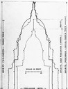
| Description: | Drawing comparing the dimensions of two Wisconsin State Capitols and the United States Capitol. |

| Date: | 1906 |
|---|---|
| Description: | Polyconic projection. Map made from surveys without spirit level control. Henry Gannett, Chief Topographer. Topography by Van H. Manning and Nat. Tyler, Jr... |

| Date: | 1914 |
|---|---|
| Description: | Advertising poster for a demonstration of International Harvester oil tractors at Grant Park, Illinois, on September 16. Includes the text: "Watch the 12-2... |

| Date: | 04 16 1971 |
|---|---|
| Description: | Large poster advertising the schedule for the University of Wisconsin-Madison Badgers football team. Printing done with red and blue ink. |
| Date: | |
|---|---|
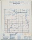
| Description: | Rural electrification survey map of Marquette county in Westfield township. |
| Date: | |
|---|---|
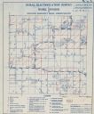
| Description: | Rural electrification survey map of Waushara county in Springwater township. |
| Date: | |
|---|---|
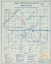
| Description: | Rural electrification map of Dodge county in Elba township. Title at top reads: "Rural Electrification Survey by Work Division of Wisconsin Emergency Relie... |

| Date: | 1915 |
|---|---|
| Description: | Poster with the emblem of France, which consists of the letters "RF" (Republique Francaise). Between the letters is a fasces with an olive branch wrapped a... |
If you didn't find the material you searched for, our Library Reference Staff can help.
Call our reference desk at 608-264-6535 or email us at: